
What a weeklong weather story Hurricane Erin has been. We’ve got state assistant climatologist Corey Davis here. Corey, what have been the impacts along the coastline from Erin as it’s starting to move away from the North Carolina and South Carolina coast?
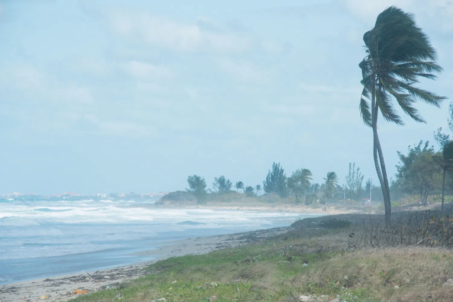
“Well, you said it, Kyle. We’re watching Hurricane Erin pull off to the northeast this morning, but still getting a feel for what the impacts have been. I’ll credit the National Weather Service. Their messaging has been spot on. They have been cautioning these coastal areas that this would be a long-duration event. We started seeing those impacts, actually, on Tuesday afternoon, a couple hours before the Tuesday high tide, started seeing that over wash along Highway 12 in places like Buxton. That has picked up, especially during the day on Wednesday. By Wednesday night, there were stretches of Highway 12 in Hatteras that were completely underwater. So certainly now, as we start to assess the damage, it looks like that over wash, that erosion in our coastal areas — those are the big stories from this storm. For most of the state, this is just going to be a close call. But for those coastal areas, it was a little bit too close — those tropical-storm-force winds at the coast, and again, especially that wave, that water damage — that is going to be a pretty memorable impact from Hurricane Erin.”
How long will it be until the red flag warnings are rescinded along the beaches?
“Well, again, even though Erin is pulling away from the shore this morning, it is such a massive storm that it’s still going to keep having an impact, at least through the day here on Friday, and you could possibly still see some high rip currents over the weekend as well. So, as you mentioned, those red flags up at the lifeguard stands — they may not be going anywhere anytime soon. One thing to keep in mind is that even though Erin weakened — it was a Category 5 last weekend — I actually think it didn’t do our coast any favors by weakening, because that weakening was triggered by an eyewall replacement cycle. When that happened, you get that eye expanding, and you get some of that strongest wind energy that moves further out from the center. On Wednesday afternoon, as Erin was approaching the coastline, we were seeing tropical-storm-force winds more than 250 miles out from the center. So even though the center of the storm stayed more than 200 miles offshore on Thursday, we still saw that widespread high wind and wave damage at our coastline.”
One thing I’ve noticed in looking at the forecast — I don’t see a lot of 90-degree days anymore, especially in the Raleigh area. Have we seen the last of the 90s, and are we heading into more 70s and 80s for the next week or two?
“Well, we can’t say goodbye to the 90s for sure just yet. So in the Raleigh area, the last 90-degree day is typically sometime in the second or third week of September. We’re still about a month away from sort of getting out of that window. But you’re right. The weather, really, all month in August has been much more pleasant than what we were dealing with back in July. Earlier this week, we had an afternoon where it never even made it above 80 degrees. And you’re right — in the forecast, we’re looking at a lot more upper 70s and some low 80s through the weekend. We may see a brief warm-up by Monday, but it looks like we’ll be back on the cooler side again by the middle of next week. One big reason for that is that we’ve seen a series of high-pressure systems build in from the north that has funneled in a lot of that cooler air. And thinking back to Hurricane Erin, that acted like a roadblock that helped steer Erin away from our coast as it moved in. So again, we can thank that high pressure not just for the nice weather, but also for saving us from a more widespread impact from that storm.”
We’ve talked about how wet July was and parts of August. What’s the update on drought conditions? I know last time there were still a few pockets of drought in the Carolinas.
“We do, and we’ve got a nice milestone this week — we are now free of any drought or dryness across the Carolinas. Now, this is not the first time this summer that’s happened. Back in early July, we also got rid of any lingering drought. Again, we know how wet the early part of the summer was, but there were also some areas — especially in upstate South Carolina and in the central coast of North Carolina — that had missed out on some of that rain. Back in July, especially, we had seen some of that dryness and a few spots of drought creep back in. But just thanks to some of the pop-up showers and storms we’ve seen over the past couple weeks, that was enough to get rid of those dry spots. The New Bern area — they had about five and a half inches of rain over the past week, and none of that rain was from Erin. Erin was not a rainmaker in the Carolinas. So again, just thanks to that normal summer rainfall activity, we are back to a neutral condition, essentially, on the drought map. I know the farmers are going to be happy about that as well. We see that in some of the crop progress this week. Last week, we talked about how the corn had started hitting maturity in North Carolina. Well, this week, we’re up over 50 percent of corn that’s reached maturity. So that is definitely a nice milestone for the farmers out there, and it looks like with that nice weather over the next week, they will have some really good conditions to be able to get out in the fields.”
We’ve been talking about Erin, but we’re starting to hit the peak of hurricane season. Are there any systems out in the Atlantic that we might need to watch in the next week or two?
“Well, certainly keeping at least one eye on a couple systems that are following behind. The Hurricane Center has been tracking these all week. It looks like their chances of developing into a named storm are increasing, but also it looks like their chances of affecting land are decreasing. One of those systems is just getting to the Leeward Islands right now. It’s about to take that same turn to the north like Erin took, but it looks like it should stay a little bit further off to the east. By this time next week, we’ll probably be talking about more rip currents, more high surf at coastal areas — but not as big of an impact from this storm, it appears, as what Erin had. Then there’s one other system that’s just moved off the coast of Africa earlier this week. Its chances for development are not quite as high. Now, we will see this sometimes when you get a sequence of systems like this — each of those churns up the water a little bit, makes it tougher to pull that moisture, that energy, off the ocean, so we can have lower chances of development. But still, it’s a non-zero chance we could see more of these storms forming over the next few weeks. And like you said, Kyle, we are less than a month now from the typical peak of the season, so we can almost guarantee that Erin will not be our last storm this year. We expect to have more, especially as we head into September.”
And what’s the forecast looking like for the weekend so people can plan their activities?
“Yeah, we talked about that nice cool weather that we’ve had lately, and that’s what we’ll see really through at least the first part of the weekend. This afternoon, highs will be up into the low 80s. By tomorrow, maybe getting into the mid-80s, especially in some eastern areas. It looks like Sunday, we’ll have a little bit better chance of rain, especially the further west you go, but still only scattered showers. Looking at mostly sunny conditions through the weekend. Monday will probably be the warmest day of the next week — maybe some upper 80s in spots. But then another one of those northerly high-pressure systems will build in by Tuesday, and that’ll knock our temperatures back quite a bit. Looks like the highs on Wednesday may again be in the upper 70s. And I am really looking forward to next Thursday morning — that could be our first chance at some upper 50s for this season. I always mark my calendar for August, because that’s usually when we get our first taste of that nice, crisp fall air. And it looks like it may be coming in less than a week.”