
After a wet July, it’s kind of been a real dry August. Really haven’t seen much in the way of precipitation. I’ve got state assistant climatologist Corey Davis here. Corey, what’s going on with this dry weather pattern, and is it going to continue, or is the trend going to maybe get a little wetter as September rolls around?
“Well, Kyle, you said it. We finished July on such a wet note and even started August on a pretty wet note, especially across the Piedmont and Upstate and the Carolinas. But what we’ve seen, especially as we crossed the midpoint of August, was a switch to a much drier pattern.”
“Remember, we even had Hurricane Erin off the coastline — it brought very little rainfall to those coastal areas. So, it’s mainly in the northeastern part of North Carolina and then down into the Sandhills of North and South Carolina where we’re seeing the driest spots right now. In fact, we’re now back in the abnormally dry category on this week’s U.S. Drought Monitor map.”
“In terms of a lack of rainfall, it’s now been almost two weeks in a row with no measurable rain in the Raleigh area. Some places like Greensboro are now at 20 days since they last had any rainfall. So, these are some pretty significant dry streaks that we’ve stacked up here since the middle of August.”
“Now, one thing you may be thinking is that after that many dry days in a row, how are we not in drought already? And there are really a couple of reasons for that. One is that we were so wet leading into August — especially back in July — that it really topped off our moisture supplies, especially in the soils and in the streams. That’s given us a nice buffer during this recent dry spell.”
“Also, the temperatures have been cooler here, especially since the middle of August. That has limited the evaporation, so we’re not losing as much of that moisture as we would in, say, a typical hot August or hot summer month. So that has shielded us a little bit from some of the impacts. But we are starting to get a few of those now. Those dry days continue to add up.”
Now, as far as the farmers go — you know, we’re talking about these dry conditions and a lot of the moisture still being in the ground — how’s that affecting the farm fields out in North and South Carolina?
“Well, I think for the most part, the farmers are not too distressed right now. But we have seen some more impacts this week. One of those is that soil moisture conditions are beginning to decline. We’re now seeing almost half of the topsoil moisture in North Carolina rated as either short or very short. That is a huge increase from where we were just a week or two ago.”
“Looking at what some of the ag extension agents across eastern North Carolina have reported over the last week, in some areas, they are seeing some leaf wilt on crops like soybeans and cotton.”
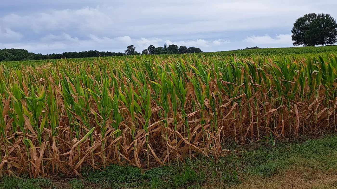
“Another one that’s interesting — and that we’ve talked about in recent weeks — is the corn. Now, most of the corn in the Carolinas is mature by this point. A lot of that corn has already been picked. But in some areas where there’s still corn out in the fields — like in Bertie County in northeastern North Carolina — we got a report this week that they’re starting to see the leaves rolling on that corn crop.”
“Now, if this was happening early in the growing season — let’s say in May or June — that could be a big concern, because leaf rolling is certainly a sign of drought stress. It’s a sign that you may see reduced yield. But since this is happening after pollination here late in the growing season, we’re not too concerned about that right now. Really, that’s just the corn’s own defense mechanism trying to hold on to as much moisture as it can.”
“So, we’ll hope to get a little bit of rain here over the next few weeks before that final bit of corn makes it out of the fields.”
Now, I know we talked last week about a “false fall” with all these cool temperatures. Is that going to continue, or do we see a warming trend coming up as we head toward the final days of summer?
“Yeah, I think the forecast is going to prove that we have been in a false fall over the last week or two. There’s been a steady warmup here over the last few days. Like you said, we went from the upper 70s earlier this week to now the mid-80s, and we’ll continue to warm up — especially this afternoon and on Saturday.”
“It looks like high temperatures across eastern North and South Carolina will make it up to around 90 degrees and maybe into the low 90s in some spots. Keep in mind, in the entire month of August, we only had one 90-degree day in the Raleigh area, and it looks like we’re about to add two here in early September.”
“But for the folks that really like the fall-like weather, there’s some good news as well. We’ve got a cold front that’s going to come through on Sunday that’ll knock our temperatures back quite a bit. It looks like we’ll be mostly in the low 80s through the rest of the weekend and into early next week. Could even see another one of those upper 50-degree mornings on Monday. So that’ll be a nice reminder of the fall and where we’ve been here over the last couple weeks.”
So, reminder to make sure you have a whole season’s worth of clothing in your car.
“That’s right — and also a good reminder to have an umbrella on hand. On Sunday, it doesn’t look like we’re going to see widespread heavy rain, but as that front moves through, we will see some rain showers beginning in the mountains and then spreading across the Carolinas toward the coast during the day.”
“We’re not expecting more than maybe a quarter- to half-inch of rain in most areas. But again, we’ve had almost 20 days in a row with no rain at all. So, this is a reminder to folks that, yeah, we do still need umbrellas at times in the Carolinas.”
Well, talking about rain, let’s look over into the tropics real quick. You mentioned we had Erin a couple of weeks ago — are there any systems we need to look out for over the next week or two?
“Well, you know, Kyle, we started talking last week about a disturbance that was just about to move off the coast of Africa and start making its way across the Atlantic. We’re now seeing that system progress. It’s still very far off to the east, but the Hurricane Center has increased the chances that this storm will develop.
“It looks like it is very likely to become a named storm over the next few days. It would be Tropical Storm Gabrielle if it develops, and the conditions out ahead of it are looking pretty favorable for further development.
“One thing about this system to note is that it’s still very far out. If it reaches us, that’ll be almost two weeks from now. So, we still have a long runway to watch this storm and see where exactly it goes. Some of the forecasts that are looking a week and a half to two weeks out are showing it getting pretty close to the Carolina coastline. There are other forecasts that keep it a little further to the east and out to sea. But this is certainly a system that bears monitoring over the next week or two — just knowing that the track could be favorable to get close to us, and it may develop further and become a little stronger. That’s certainly one to watch.”
Absolutely. But a little closer in the timeframe, let’s look at this weekend. You talked earlier about some 80- or 90-degree temperatures and then that cold front coming through. What should we really expect this weekend in the forecast?
“Yeah, I think the big story is that temperature change coming this weekend. Again, low to mid-90s this afternoon and again on Saturday, with sunny skies throughout the day both today and Saturday. So, no need to worry about a rain shower if you’re headed out to a football game tomorrow afternoon.”
“The real rain chances will increase by Saturday night and especially during the day on Sunday across central and eastern North Carolina. Again, a fairly small rain chance overall. We’re not expecting a downpour, but it is worth watching for a shower — maybe even a thunderstorm out there.”
“Once we get into Monday, that rain chance will really diminish, except for some of those immediate coastal areas. We’re looking back to partly cloudy skies and temperatures near 80 degrees through at least the middle of next week. And again, back in that dry pattern. So we hope we can wring whatever rain we can out of the front this weekend, because it’s looking like more dry days ahead as we go into next week.”