
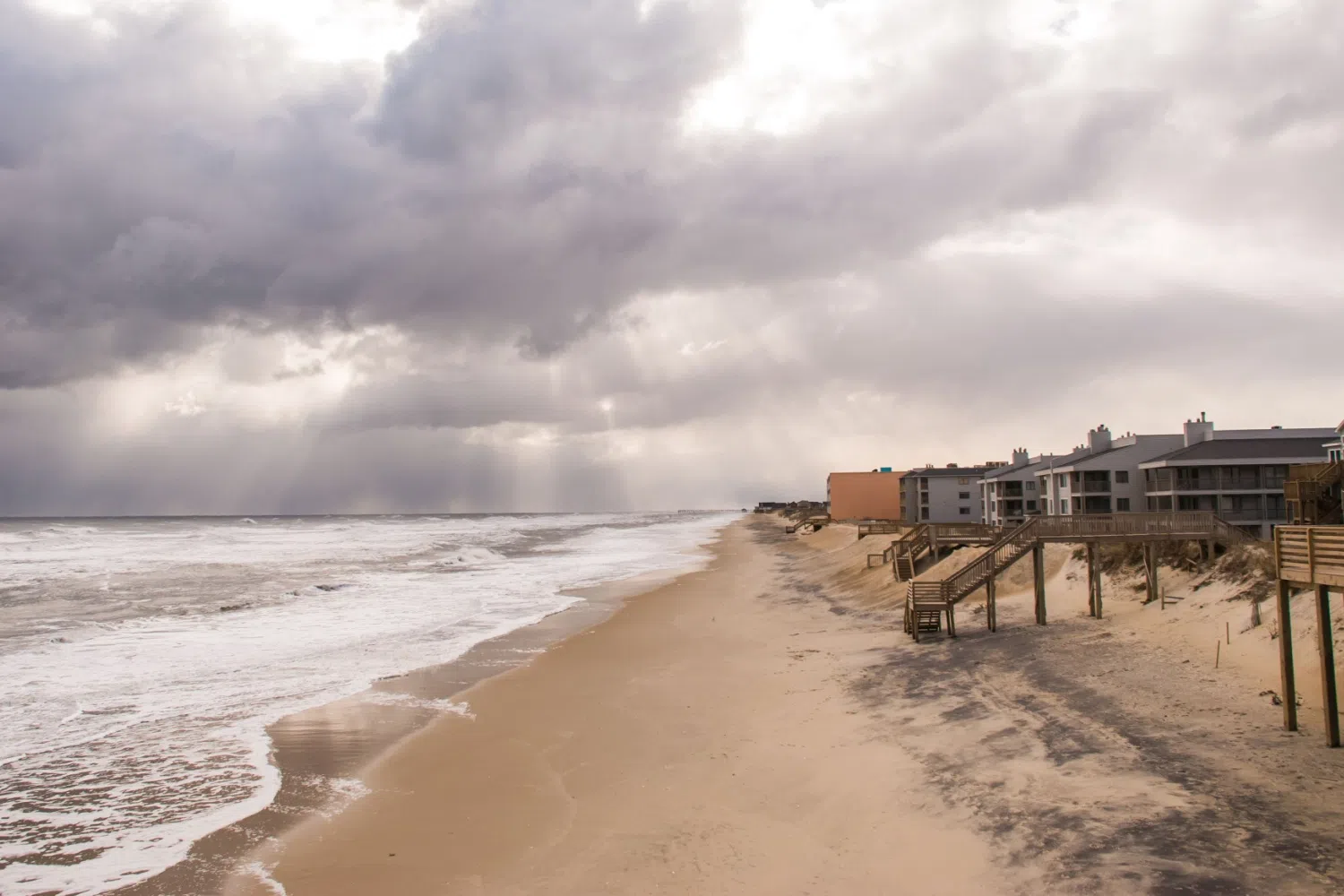
We had a big storm off the coast of the Carolinas last weekend. But how did that affect the drought maps here in the Carolinas? I’ve got state Assistant Climatologist Corey Davis here. Corey, how did the rain from that nor’easter really affect the coast? And did we see any effects here farther inland?
“Yeah, Kyle, this was the big weather story across the Carolinas over the past week. It was a non-tropical system but still a pretty powerful low-pressure system. We’ll see more of these as we start heading into the wintertime, but we did see some impressive rainfall totals, especially right along the coastline. Down in Charleston, they saw almost 3 inches. Myrtle Beach was over 4 inches, and there were pockets of eastern South Carolina and far southeastern North Carolina that saw some local totals of 5, 6, 7 inches. So again, some impressive rain amounts. But the caveat was that rain did not extend all that far inland. By the time we got to Columbia, South Carolina, we were only a little over an inch. In the Raleigh area, we only had about half an inch from that system over the weekend. And then west of there, those totals basically fell off to zero — some very dry conditions across western North and South Carolina over the past week.”
“So, when we consider the wet spots and also the dry areas, we saw really a mixture of improvements and degradations on the drought maps this week. Some of those immediate coastal areas did see some nice improvements. They’re actually back to near-normal conditions on the drought map, so no abnormal dryness in places like Charleston and Wilmington. But as we get farther inland, especially around the I-95 corridor, we really didn’t see those improvements there or west of there, and we actually saw some degradation and the emergence of some moderate drought in parts of the Piedmont in North Carolina. The reports that we’ve heard from ag folks there over the past week say that in places like Randolph County and Vance County, they’re still really struggling with a lack of soil moisture. A lot of those crops, especially the cotton that will be some of the last to finish up, are just wilting. It’s not responding to that little bit of rain they did see, and the growth is stunted at this point. Again, this is coming after almost two months of dry weather that we’ve had here late in the summer and early in the fall. So, it was nice to get the rain where we saw it last weekend, but we sure wish it would have been a little more widespread, especially to help some of those farmers out.”
Oh, we also were talking about Jerry, and that storm just curved off toward the east. Was there another storm that just happened to pop up over the last week?
“Yeah, we’ve actually had a couple of systems in the tropics active over the last week to week and a half, but both of those were kind of ‘blink and you might miss them’ systems. One of those was Subtropical Storm Karen. This formed very far north in the Atlantic, so it didn’t take long for it to move over some cooler water and eventually fizzle out. And then earlier this week, we saw Tropical Storm Lorenzo, another very brief, short-lived system. It was only active for a couple of days, and it pretty quickly started to curve off to the north as well — so no landfalls or impacts to land from either of those systems. The one thing they did do was get us a little bit closer to that average number for the year. Lorenzo was our 12th named storm in 2025; the 30-year average is about 14 storms. So, it would only take a couple more storms to get us to that average level, and that’s basically where those preseason predictions were at. We were looking at a near- to slightly-above-normal season this year. Not sure if we’ll make it to that above-normal level, but at this point we’ve got about a month and a half to maybe squeeze a couple more storms out of the Atlantic this year.”
Now, how common is it for any named storms to pop up toward the very end of the hurricane season, maybe into November?
“We are certainly past the peak at this point. And when you think about some of the big storms we’ve had in North Carolina, it is very rare to see any after the middle of October. Way back in 1954, we had Hurricane Hazel — that was right at this point in mid-October. In 2016, we had Hurricane Matthew — that was in the first week of October. But after this point in the season, it’s pretty unusual. The last storm I can think of that had an even later formation than this was Tropical Storm Nicole, which moved through parts of western North and South Carolina back in early November of 2022. So, we can’t say that we’re totally out of the woods yet, but certainly it is pretty rare to see impactful storms, especially in our part of the country, at this point in the season.”
So, we’ve got state fairs going on in both South Carolina and North Carolina. South Carolina’s fair is wrapping up this weekend; North Carolina’s just started on Thursday. What are all the fairgoers going to have to expect when it comes to the forecast?
“Well, I think down in Columbia, for the wrap-up of the South Carolina State Fair, they are looking at pretty much picture-perfect weather over the next few days. They’ll see highs in the mid-70s today with mostly sunny skies, going into tomorrow with highs around 80. Then by Sunday, the last day of the South Carolina fair, they’ll be in the low 80s, but it may be a little more cloud cover — really no threat of rain during the day. In Raleigh, as the North Carolina State Fair gets going, we’re seeing some cooler-than-normal temperatures both yesterday and today, with highs mostly in the upper 60s. That’s about five degrees cooler than normal for this time of year. We’ll be near normal by Saturday, and then on Sunday a little bit warmer than that, maybe some upper 70s. It looks like the best chance of rain over the next week will come on Sunday night, but the timing of that looks like it’s going to be later in the night — even into the early hours of Monday morning. So, I don’t think that’ll pose a real weather threat to folks out at the fair.”
“This may just be something we’re seeing overnight, and you might see a few puddles on the ground by Monday morning. And with that said, this cold front that’s going to push through on Sunday night isn’t going to have a lot of moisture with it — especially as it crosses over the mountains, it looks like it’ll dry out most areas. I think across central and eastern North and South Carolina, we may only see a couple of tenths of an inch from that system. So, we wish again we could get a little more rain out of some of these weather systems moving through, but I’m sure for folks going out to the fair this weekend, they’ll be fine with having pretty dry conditions. By early next week, we’ll be down into the low to mid-70s again — very typical weather for this time of year — and no threat of rain through the end of next week. So as far as the State Fair forecast goes, it doesn’t get a whole lot better than that.”