
It seems like only yesterday that we were starting the month of November, and now we are one week away from Thanksgiving. It gives us a chance to look at the progress report here out in the Carolinas. As far as temperature and the Drought Monitor, we’ve got state assistant climatologist Corey Davis here. Corey, how does that progress report look in terms of temperature and precipitation in the Carolinas?
“Well, Kyle, you’re right. As we get closer to Thanksgiving, that means we’re getting closer to the end of November, also closer to the end of our climatological fall, and this is a good time to check in on where things stand with our temperatures and our precipitation for the month and the season. First off, we can say November is trending toward near-normal temperatures overall. Most areas in North Carolina are maybe a degree or two warmer than normal. Down in South Carolina, we see places like Florence and Charleston — they’re about a degree below normal. But really, this is continuing a trend we’ve seen all throughout the season, even going back to August, where we’ve had pretty seasonable temperatures over the past few months. Certainly, there have been some warmer days and some colder nights mixed in, but for the most part, we’ve been hanging right around those average temperatures.
“And you’re right, the bigger story has been the precipitation — especially the lack of precipitation — that’s led to that drought development, and we are still seeing November on track to be a mostly drier-than-normal month. Most areas in the Carolinas running between one and two inches below normal. There are a few areas right along the coastline, especially out at Hatteras and up in Elizabeth City, where they’ve been a little bit wetter than normal for the month so far. But again, most other areas still running a little behind for the month and also running behind for the season.
“So, when we look back to the beginning of September, we see those deficits anywhere from 4 to 10 inches below normal, and again, at some of those coastal places like Wilmington, like Morehead City, that are actually the driest over that time period. So, no surprises there. We know it has been a pretty dry season, and one thing we’ve seen this week is an expansion of moderate drought, especially across central North Carolina this week, getting down into the Charlotte metro area, also up across the Triad, and then more of Wake County is now in moderate drought as well. Again, this just reflects those deficits that we’ve seen build up over the last few months, and also some of the new impacts that have emerged just over the last couple of weeks.”
So, it’s going to take at least a good 5- to 6-inch rainstorm to kind of even bring those drought levels just to more of a, like, almost close to zero. Am I correct?
“Yeah, whenever we start to see these deficits really get above, say, 3 or 4 inches, at that point, you’re not going to get rid of it all just in one rain event. You’re going to have to chip away with multiple events. You look back to late October, that event that we had over several days — that’s exactly the sort of event that we need to see more of — that slow, steady, soaking rain where we get an inch or two per day. It’s ideal if we could get that, all, say, over the next month, but we’re expecting it’s probably going to take several months with regular rainfall events of that magnitude.”
We’ve been talking over the last couple of weeks, talking about the dry conditions and the potential for wildfires in the Carolinas. Have we seen any instances of wildfires in the Carolinas over the last week or two?
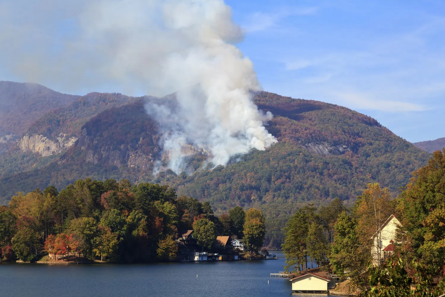
“Yeah, that’s been a big concern over the last few weeks, really, as we saw this drought start to develop and spread across more of the state, and we have started to see more of those fires pop up, especially late last weekend and early this week. That’s when we saw some of those very windy conditions, very low humidity. Those are ideal weather conditions to help those fires start and spread. We’ve seen a couple big ones, really, on either end of North Carolina. One of those was out in the mountains up in Avery County near Banner Elk. They had a fire that burned 160 acres up there. It started from a debris burn — so probably someone in their backyard was just burning some trash or debris — and then with those windy conditions, that fire spread and became a pretty big problem in that area. Fortunately, that fire is fully contained by now.
“The even bigger fire happened in eastern North Carolina. Of course, this is near that area where we’ve had severe drought on the map over the last couple months. And the crazy thing about this fire is that it actually burned in the floodplain of the Roanoke River out in Bertie County, and that’s the last place where we would expect to see a fire because it is right there at the river level. But because it’s been so dry for so long, a lot of the vegetation there, like the bald cypress, had dried out. They’ve seen that leaf litter from those falling leaves all over the ground that really fueled some of that. So that fire expanded over 500 acres earlier this week. Again, it’s also 100% contained now, so that’s good news. We’ve had a little bit more cooperative weather over the last couple days, but these are the sorts of fire events that we’ve been worried about when we’re in a drought at this time of the year. We know the last few years have had pretty similar active fall fire seasons, and we may be seeing the start of that right now.”
You were talking about the one in Bertie County, talking about how it being so rare. What do you mean by why is it so rare for a wildfire to start in such close proximity to a river basin?
“Yeah, this is an area — it’s actually part of a national wildlife refuge. It’s usually a pretty swampy area; it’s usually covered in water. You just wouldn’t expect to see fires igniting in an area that’s usually got so much water in it, but because those water levels in the river and around the swamps have dropped so much, that’s helped things dry out really quickly. And this is something that we can see in other parts of eastern North Carolina, especially as you start to get into some of the organics — those peat-like soils. They’re usually underwater, but when they’re in a drought, that water level drops and things become very flammable in those spots.”
All right. Well, let’s look at the forecast as we’ve got going on for this weekend, and also, like I said, we’ve got Thanksgiving coming up next week. So, what’s the forecast looking like just for this weekend, and let’s look ahead toward Thanksgiving?
“Yeah, we can start with today, and we’re going to see a nice warmup this afternoon. We’ve been mostly in the 60s this week, but the high temperatures will reach at least the mid-70s by later in the day today, possibly some upper 70s by Saturday afternoon. But we’re also going to see a warm front lift northward across the Carolinas really late tonight and into the early hours of tomorrow morning. That will, of course, fuel some of that warming that we’re seeing but also bring in some moisture. So, it looks like we’ll see a decent chance of rainfall, especially late tonight and early tomorrow morning. The amounts are not going to be that great, probably less than a quarter-inch of rain in most areas. But again, if you’ve got plans, especially outdoors first thing in the morning, maybe carry that umbrella with you because you could see some showers, possibly even a scattered thunderstorm out there early on Saturday.
“After that, we’ll see temperatures really level off by Sunday again, back in the mid-60s. And then as we head toward that travel time for Thanksgiving, next Wednesday looks like it could be a little bit more active in terms of weather. A cold front should move through by late next Tuesday night, and then during the day on Wednesday, again, expecting to see some rain showers with that. It looks like the overall coverage may not be that great, and probably the totals are going to be no more than maybe a quarter- to half an inch. So again, something to watch for, Kyle. As you know well, anytime we start to see wet weather plus lots of traffic on the roads, that can make for a mess.”