
Well, Christmas has come and gone, and we did not have a white Christmas. It was sunny and warm. But are white Christmases around the Carolinas rare? Do we see them a lot? State assistant climatologist Corey Davis here. Corey, how rare is a white Christmas in the Carolinas, outside of the mountains?
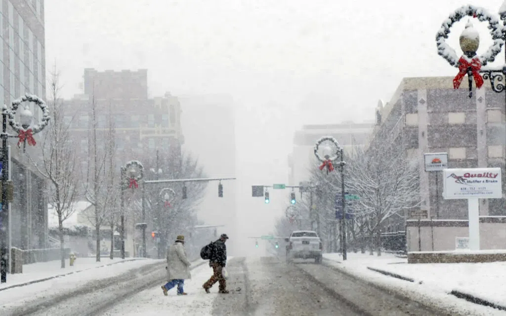
“Well, Kyle, for weather watchers, it always feels a little bit like getting coal in your stocking when you have a Christmas this warm. But historically, we have not had that many big white Christmas snow events, especially in Central and Eastern North Carolina. The Raleigh area has about a 2% chance of seeing snow on Christmas in any given year. That’s about a one-in-50 occurrence on average. So, we tend to talk, to talk about white Christmases as a once-in-a-generation sort of event. Now, you’re right — in the mountains, it is a little bit more common, but even the Asheville area only has about a 6% chance of seeing snow on Christmas. So definitely a rare event there as well. And then, if we go back prior to 2010, the previous snowy Christmas had been in 1993, and before that, in some places like Raleigh, not since 1947 had they actually had snow falling on Christmas. So definitely a rare event, historically. But for folks who have been around the Carolinas over the past couple decades, that all changed in 2010. That was not looking like a very favorable winter for snow. Initially, we’ve talked about the La Nina pattern that’s in place this winter that tends to favor warm and dry weather. Well, there was even a stronger La Nina pattern in place going into that 2010-2011 winter. We just really didn’t think we were going to see much snow at all. And then, the first couple weeks of December, we saw some cold weather. We saw some snow. And then, going into that week of Christmas, the odds really started to ramp up. And ultimately, we did see a solid snowstorm over Christmas Day and the following day that year.”
Absolutely. I know you’re talking about the one in 2010 where, you know, people around the Carolinas woke up to a white Christmas. How did all of that unfold?
“I think for a lot of people, their main memories of that event is, like you said, seeing the snow falling on Christmas Day, or if you were in the Raleigh area and places further east, then maybe staying up late that night and early the next morning and seeing a really solid snow on the ground. Behind the scenes, as a meteorologist, I can tell you this was something of a nightmare event to forecast, because that snow never seemed like a sure thing. We started seeing hints of maybe a weather system about a week beforehand, but basically every day, we were seeing big shifts in the major forecast models. Some of them would show it might be too warm for snow. Some might show it would only be light snow, but nothing major. And then you would have some runs that would show a significant, monster snow event unfolding on Christmas Day. And we kept seeing these big shifts back and forth.
“Now, the big challenge there, the big reason we were seeing those shifts, is because the models were trying to make sense of what was happening in the upper atmosphere. There were waves of energy in the jet stream that would eventually meet over the Southeast U.S. But as we see in any sort of snow event, even nowadays, we are very sensitive to exactly where that energy meets up and where the surface low-pressure system forms. Some of the forecasts were showing that energy combining a little bit too far east, which would keep most of the moisture offshore. Some of the forecasts showed that energy meeting farther west, which would form that low a little bit too far inland and make for mainly warm weather across the Carolinas. It really took that perfect combination, where that energy would meet and form that low right off our coastline, that would bring all that moisture into a cold air mass across the Carolinas. And ultimately, that’s what happened.
“So, I know a lot of folks are very excited that’s the way it panned out. But again, trust me, for meteorologists, that never seemed like a guarantee. And it really took until late in the day on Christmas Eve before most of the forecast models started to line up and show that kind of snowy solution.”
So, this isn’t the first time in the Carolinas we’ve had a weather event that, almost seemingly to the viewer’s eyes, came out of nowhere, and there really was a nightmare behind the scenes over at a lot of weather centers. How unreliable at the time was that forecast and being able to accurately project and predict and tell the viewers what was coming?
“Yeah, you’re right, Kyle. That early-2000s era was really hit or miss, especially when it came to these significant winter storms. A lot of folks in the Raleigh area will remember 10 years before that Christmas storm, back in January of 2000, it looked like it may be just a two- or three-inch snow event. They ended up with 20 inches on the ground. The opposite happened later that year. There was a storm that looked like it may be a big snowmaker, another potential one-foot-plus event, and there were barely even any flurries after that one.
“I will say that that decade was really challenging, again, for forecasting these major winter storms, in part because there were so little model data available. There were really only three major weather forecast models that forecasters would rely on, and even then, they could be out to lunch. And you really, really wouldn’t know it because there were just so few options.
“What we’ve seen, especially beginning after that 2010 storm, is something of a technological revolution. We have seen more models come online. Many of these model systems now include a number of what we call ensemble members. That means we just have slightly different models where the initial conditions may be tweaked a little bit, and if they converge on the same outcome, that gives us a lot more confidence in what may happen. We also see that these models have gotten better. They’re now higher resolution, which lets us pick out features like snow bands that may set up across the Carolinas. And also, the data that we rely on from the atmosphere, especially the upper levels of the atmosphere, has gotten a lot clearer and a lot better.
“So, thinking back to that 2010 storm, we were trying to predict what these waves of upper-level energy might do. Now, we have a little bit clearer picture, a little bit farther out, of what those systems look like, how strong they are and when they may converge.
“Now, all that’s to say snow is still something of an inexact science in the Carolinas for multiple reasons. One is because you’re relying on these features in the atmosphere that are thousands of miles away to pretty much hit an exact target to see a decent snowfall. We know that temperatures are often a challenge in this part of the country as well. One degree too warm, and you may see a big snow event change over to a freezing rain or a rain event. So, we have definitely gotten better at predicting these winter storms over the last 15 years, and I like to think if we had an event like that 2010 storm again today, we would at least know with confidence farther ahead of time that there would be that chance of some pretty significant snowfall.”
Well, I was getting ready to ask what has happened to improve the forecast since then, but you just so eloquently put it out there. The technology has improved. And as much as we sit here and go, ‘Oh, technology is really the downfall of society,’ it’s really helped us be able to look at the atmosphere, look at the weather patterns and go, ‘Hey, we have this serious storm coming up, and we really need to prepare for it.’
“That’s right. And there are a couple other innovations we can highlight. These were just coming online during that Christmas 2010 event. One of those is the way we get snowfall observations from the public. There’s a program called CoCoRaHS. It’s the Community Collaborative Rain, Hail and Snow Network. Basically, this relies on volunteers, weather observers, to go out in their backyard every day and make rainfall measurements. If we do have a snow event, they make their snow measurements and then report those in. And that gives us a really good idea about where some of the highest snow totals have fallen.
“Looking back at that December 2010 storm, without those observers, we may not know where the highest totals occurred. We knew there was about a foot in the Rocky Mount area, but a little bit closer to the Virginia border, up in Northampton County, there were several observers who reported almost 15 inches of snow. So again, a really solid snow event and one of the biggest areas have had so far this century.
“Another innovation — and this is something our office has been a part of — is our soil temperature measurements. This gives us a good idea about when snow might stick. Going into that Christmas 2010 event, the soil temperatures were in the upper 30s and low 40s. That told us the ground was already pretty cold. It would not take that many hours of snow falling before that snow began to stick.
“And that is my main memory of that event. I was in the Triad. We were opening presents as a family. My mom looked out the window and said, ‘I think it’s snowing.’ And sure enough, the snow had started there just before noon on Christmas Day. It kept falling the rest of the day. We ended up with about six inches from that event. And it was very rewarding, as an undergrad meteorology student, to see what I was watching in the forecast all pan out with just that beautiful Christmas snow across the Carolinas.”