
Happy New Year to everyone listening. 2025 was a unique year here in the Carolinas. We had some drought. We had some tropical systems. Let’s talk about it with state system climatologist Corey Davis. Corey, talk to us about how 2025 was in terms of temperature and precipitation, and how that ranked in the Carolinas.
“Happy New Year, Kyle. One of my favorite things about this time of the year, aside from the holiday season, is that we really get to close the book on one year in our weather. We get to think about how the story of this year will be told going forward. And you’re right, for 2025 there were some really unique and interesting story lines.
“First, just thinking about how our temperatures played out over the year, folks will remember those few really cold weeks that we had back in January, along with some snow for the first time in several years. So, it certainly got off to a cold start to the year, but we warmed up pretty quickly after that. February was warmer than normal. We were warmer than normal all through the spring. In fact, it was the second warmest April on record in North Carolina.
“And then that warmth carried over into the summer as well. We had some of those hot, 100-degree days back in June, and then July was also the second warmest on record in North Carolina. The most memorable thing about that month was not those afternoon highs, it was how warm those overnight lows were. Just some really sticky, humid weather in those overnight periods, really uncomfortable to be outside at any hour of the day.
“So, I know by the end of July, folks were sick of the heat. They were ready for summer to be over, and right on cue, we got into a much cooler and cloudier weather pattern for August. And we’ve really stuck with that seasonable weather over the past three or four months. Fall was pretty much close to our normal temperatures. And then, of course, in December, we had those back-and-forth temperatures from the cool start to the warm ending.
“For our precipitation patterns, for the most part, we’re looking at dry conditions throughout 2025. It was dry coming into the year, including in the end of winter. It was dry to start the spring. We finally got into a wet pattern by May, and it was the fourth wettest May on record in North Carolina. We continued seeing mostly wet conditions through the end of summer. And then once we got into mid-August, and especially early September, we flipped back to a dry pattern. And that’s where we’ve been basically over the last four months to end the year.
“So overall, North Carolina, through the end of November, was on pace for its 16th warmest year on record, and also the 11th year in a row that was warmer than normal. And then for precipitation, we’ve been tracking as the 34th wettest year on record, dating back to 1895. That is very similar to where we finished in both 2022 and 2023, so the sort of dryness we’ve seen quite a bit. And thinking about when that dryness happened, especially in the fall, also very similar to some of those recent years in 2022 and ’23.”
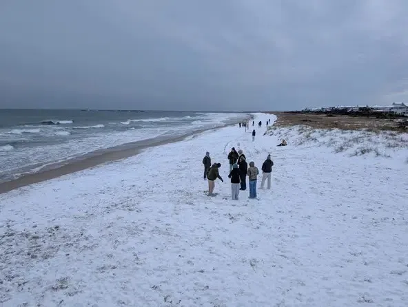
Now, a couple story lines that we were watching throughout the entirety of 2025, one of them was some early snow that we had. You briefly touched on it. Talk a little bit more about that snow event that happened in the beginning of the year.
“Yeah, this was a long-awaited snow, because most areas across the Carolinas, at least outside of the mountains, had not seen any accumulating snow in almost three years, going back to late January of 2022. Since then, we had had a couple very warm winters where we really just never saw those snow chances pan out.
“So, we were wondering last year, especially going into a La Niña winter that tends to be warm and dry, whether that drought would continue. And it turned out, by the time we got into the middle of January, we did see some cold air move in, and we saw several shots of moisture that produced several different snow events. One of those in mid-January, one in later January, and then some coastal areas also had some snow in February.
“So altogether, those events added up to an above-normal snowfall season for parts of eastern North Carolina. Places like Raleigh and Greensboro were still below their annual average snowfall, but still the first time they had seen that much snow in several years. So again, that definitely will be one of the big memories of 2025. It’s the time when snow finally returned across parts of the Carolinas.”
And looking at the other end of the spectrum, another storyline here in the Carolinas has got to be talking about the drought. And that drought map has seen some fluctuations over the past 12 months. Talk a little bit more about that.
“Yeah, we talked about the end of the snow drought, but there was not much of an end to the actual hydrological drought. We had drought in place coming into this winter. Folks will remember, after Hurricane Helene last fall, we shifted into a dry pattern almost immediately. And we had drought in place across the Carolinas throughout the winter.
“That drought lasted into the spring. And again, finally, we got into that wet pattern in May and early June that wiped the drought off the map, which is a big relief. But it didn’t take long before drought started to creep back. We got into another dry pattern by mid-August, and we have stayed dry for the most part over those last four to five months.
“The one interesting thing, talking about the drought and our precipitation, is just that we have seen a very uniform level of dryness, especially across North Carolina, over those past 12 months. Most areas are running somewhere between 75 to 90% of normal. That corresponds to about a five- to 10-inch rainfall deficit.
“The reason that’s unusual is because normally, if we see dry conditions over a long period, like a year, we would expect some areas naturally would just be unlucky and they would miss out on more of those rain events. But instead, it seems like pretty much the entire state has uniformly missed out on the rain at the same time. So, other than a few parts of the Central Piedmont that did have some heavier rain last summer, we’re pretty much below our normal rainfall statewide over the past year.”
And you definitely led into the final storyline, Tropical Storm Chantal, which just barreled through central North Carolina. Talk a little bit more about that.
“Yeah. You know, this was a near-normal tropical season overall, but the old lesson is that it only takes one storm in your area to be an impactful season. And that was definitely the case for those parts of the Central Piedmont that saw so much rain and flooding from Chantal back in early July.
“Again, thinking back to what was happening at that time, we were coming off of a fairly wet pattern in May and June. We really didn’t need much more rain at that time, because drought was not an issue. And then along comes Chantal.
“Now, this was a fairly weak storm, a weak tropical storm at that, but it stayed off our southern coastline for several days, all the while it was picking up that moisture off the Atlantic. And then as Chantal started moving to the north, it took a little bit of a jog off to the west, and that dropped those heavy rainfall totals in areas that really aren’t used to seeing that sort of impact from tropical systems.
“We saw eight to 10 inches in places like Chatham, Alamance and Orange counties. And a lot of that rain fell over the course of just 12 hours. So, some really immense rain rates in those areas. And that led to the Haw River and the Eno River reaching record levels and breaking the records that were set during Hurricane Fran, which was such a memorable and impactful event back in 1996.
“So, I think the big lessons from Chantal are that it does not take a hurricane to have a big impact, especially with rainfall. Chantal was only a tropical depression when it moved across central North Carolina. But also, this adds to the lesson we’ve learned with other recent storms, like Debbie back in 2024 and that Potential Tropical Cyclone Eight in September of 2024, that a fairly weak system can still have a really big impact when it sits over that open ocean for several days and brings so much moisture in.
“So, I think maybe 10, 15 years down the road, when we look back at 2025, it will probably be that impact from Chantal that we remember the most as the biggest weather story from this year.”