
For the second straight weekend, we had winter weather gracing us with its presence, but unlike the previous week, it was ice in a wintry mix. This week was all snow, and we had one anomaly in the Raleigh area. Oh, let’s talk about all of this with state assistant climatologist Corey Davis. Corey, I guess snowmageddon. We have survived it. Who got what around the Carolinas?
“And we made it, Kyle, the big snow event of the year. I feel fairly confident saying that. And for most areas, this was the biggest snow event they’ve seen in several years, even in decades, for parts of eastern North Carolina, and that’s a good place to start. Those were the highest totals of more than a foot across a pretty broad area from Jacksonville up toward Kinston and Greenville, and really all the way out toward the coastline. In fact, some of the highest totals were right along the coastline, down along the Crystal Coast, in parts of Onslow and Carteret counties. They got upwards of 20 inches of snow from this event, so the biggest snow those areas had seen since the 1980s, such a rare event that especially in that part of the state, we just don’t see a lot of snow at all, especially in that amount.
“As we headed further inland and especially across the western part of the state, we also saw places that saw a foot out there, right along I-85 just north of Charlotte, up through about Greensboro, about a foot on the ground. Some of our high-elevation mountain areas also saw a foot. And even down in South Carolina, we saw six to seven inches out in the Greenville and Spartanburg areas, really a solid snow all the way to the coast in South Carolina.
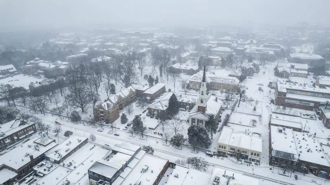
“But as you mentioned, Kyle, that one part of the Carolinas that did not get as much was really centered right over Wake County. This was admittedly something that the forecast had started cluing us into. At this point last week, it looked like a dry slot may set up right over the Triangle area northward to the Virginia border. What we ended up seeing during the storm is that they did get some snow, but that snow didn’t start moving in until later on Saturday night.
“The big reason for that is that we had an upper-level low-pressure system out across the western part of the state. We had a surface low-pressure system developing offshore. Really, in between those areas of low pressure, we got sinking air, so that kept us from developing any snow showers over the Raleigh area. Again, it did finally fill in later on, but we certainly saw that reflected in the totals. Instead of seeing those six to eight inches like the rest of the Piedmont, Raleigh was more like two to four inches. And there were some places in south Raleigh and Garner that barely even got an inch and a half. So, I know those places, especially if you like the snow, were probably a little bit disappointed by this event. But we can say for the rest of the state and for the rest of the Carolinas, this was a monster snowstorm.”
Yeah, I was seeing footage of areas like Myrtle Beach with five or six inches, and Greenville and around the Wilmington area. So, it’s insane to see all this snow in areas that you don’t typically see snow, like coastal areas. I was reading an article in Greenville where they had to get snow-removal equipment brought in because they typically don’t have to worry about this. But the one question I have to ask: All this snow in all these areas, where is the snow going?
“Well, it’s not going anywhere fast, and that’s mainly because we’ve had such cold temperatures all week. Our afternoons have barely gotten above freezing, really only for a few hours, especially in those places that have that heavier snowpack still on the ground. Talking to some folks out in eastern North Carolina early this week, they said they picked up over a foot last weekend. They still probably had six or eight inches on the ground yesterday. So again, it is just not melting very quickly.
“Usually when we see a snow like this, we expect that snowmelt will eventually send some moisture down into the soil that will rejuvenate our soil moisture levels, and then that runoff will make it into our rivers and streams. We really haven’t seen that moisture boost yet, and again, one of the reasons is that we just didn’t see that snowmelt starting very soon, but also because the ground is still frozen in a lot of areas. Again, it’s been cold all week, and that means that it’s just like a barrier for that moisture that can’t make it into the ground.
“The other factor is something that we don’t see very often in the Carolinas. Snow lovers would say this event was sublime, but what we see afterward is the snow is sublimating, and that means that it’s going straight from its icy solid state directly into a gas. It’s turning into water vapor, so it’s not even going through that liquid phase where they would allow it to soak in. And that certainly will reduce the impacts that we see, especially on the drought map.
“We didn’t really have any changes, no improvements this week. I think we may see some gradual improvements over the next couple of weeks with whatever melt we do get. But also keep in mind the liquid totals for this storm were fairly low. Even in those areas that saw upwards of a foot, that was only about an inch of liquid precipitation. So that’s really only about average for a week at this time of year. So again, all those factors mean that we’re not seeing that snow go away quickly, and we’re not seeing the benefits that we would hope for, especially in our drought-affected areas.”
Well, you talked about the drought map, but let’s move on a little bit. How is this going to impact the farmers? All the snow coming in, and a lot of it just evaporated, not even getting into that liquid state. So, what’s the ag impact for farmers looking like after the storm?
“I’ll say it’s a little bit tough to assess the impacts right now with all that snow on the ground, but we did get the first USDA crop progress report of the year back earlier this week, before the snow event. Not a whole lot to report on there, but one thing that really stands out is the status of the pastures right now across North Carolina. We know even coming into the winter there had not been a lot of rainfall. The pastures weren’t in great shape.
“But now here in early February, we’re seeing 60% of the pastures in North Carolina are in poor or very poor condition. Another impact that we see is a lot of those farm ponds are very low. We heard from folks in Harnett and Wake counties this week, some of the areas that saw those lower snow totals anyway, and they said that the ponds there are lower than they’ve been in years, even over the wintertime. So really all that speaks to the problem we’ve had all season, and that’s we’re just not getting the moisture recharge that we had hoped for. We haven’t had that many rain events. As we mentioned, this snow event has been slow to melt, and we may not see a lot of the benefits when it does melt. So that really means those winter crops and some of those farm ponds are still in pretty bad shape as we come into the month of February.”
All right, well, let’s take a look at the forecast, and let’s break this two-week streak. Are we going to have any winter precipitation this weekend, or are we done with it for at least a week?
“Well, there’s some good news and some bad news, but we can at least say we’re done with winter precipitation for the time being. We teased it last week, but we’ve seen a relative heat wave over the last few days. Back on Wednesday, we saw those high temperatures up into the 40s for the first time in what seems like ages. We’ll also be up in the 40s this afternoon.
“Now yesterday morning, we did have some snow and ice in parts of North Carolina, a few slick spots on the roads out there, but that should be the last bit of frozen precipitation that we have to see falling for a while. Certainly, some of that snowpack is going to stick around for a little while longer, especially in those spots that got upwards of a foot as we go through the weekend.
“There is another cooldown coming. It’s another one of these Arctic high-pressure systems that will funnel south. But the good news there is that we are not going to see those highs in the 20s like they’ve been the last couple of weekends. Instead, it’ll be more like low to mid-40s on Saturday and Sunday, and then as that high shifts to our south, it’ll put us in more of a southerly or southwesterly wind pattern. That’ll let us warm up pretty quickly early next week. In fact, some of the high temperatures we’re seeing for Tuesday and Wednesday are showing mid to upper 50s, so that will definitely feel like a heat wave compared to where we’ve been over the last couple of weeks.”