
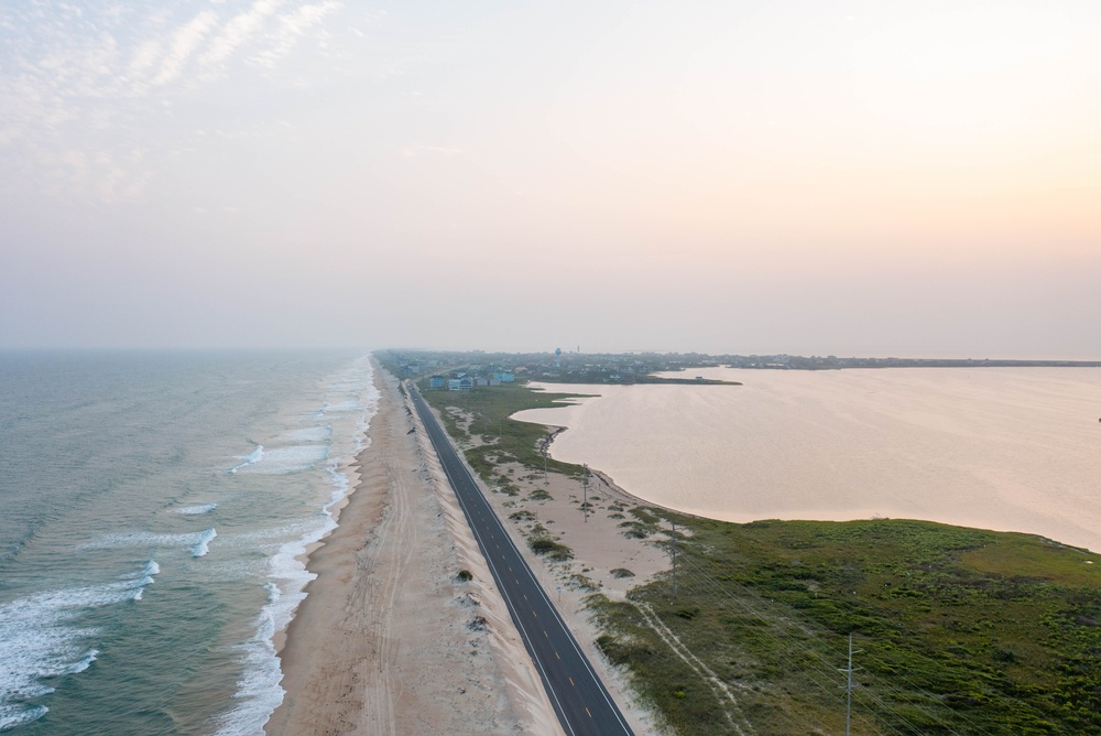
So, we had the nor’easter come through this past weekend. We had rain up in the Northeast, but the coast of North Carolina was not spared. Did not see a lot of rain, but you saw a lot of wind and surf damage that took out Highway 12 around the Outer Banks. So, we got State Assistant Climatologist Corey Davis here. Let’s talk about this nor’easter. How did it affect North Carolina and South Carolina? And did we see a lot of rain coming through the area that the Northeast saw because of this nor’easter?
“Yeah, Kyle, I think it’s safe to call that event the defining weather event of the month of September, at least in the eastern U.S. Again, a strong low pressure system that formed off the coast of the Carolinas late last week. As you said, we felt the impacts, especially up along the Outer Banks. We saw that washout and damage on Highway 12 and P Island. Of course, that’s an area that seems to see the worst of those impacts just about every year. And we know it doesn’t take a hurricane, it doesn’t take a named storm, even a strong system like this nor’easter, have big impacts in that part of the coast.
We also felt some strong wind. Up in Elizabeth City, they had wind gusts up to 44 mph last week. Down the coast at Hatteras, they were also feeling those tropical storm-force wind gusts. And then you mentioned the impacts that the northeastern part of the country had. Parts of the coastline, like up in New Jersey, had two to three months’ worth of rain in just a few days. So, again, a strong system. I think that kind of gives us a preview of what we can expect more of this winter. We know in these El Niño patterns, we tend to see more coastal storms like that.
The one thing that we didn’t get in the Carolinas, like you said, was rain. Unfortunately, these eastern areas are the places that need the rain the most right now, and they’re the places that saw the least of anybody last week. Parts of far eastern North Carolina, like along the Outer Banks, had less than a tenth of an inch of rain in total. Across most of the coastal plain, we saw less than half an inch, and it really wasn’t until we worked our way further west, like back toward the mountains, that we saw some of the higher rainfall totals. That was mainly from the cold front that moved through earlier in the week, but that was the one bit of good news in terms of drought conditions this last week. Some of those western areas saw two to four inches of rain, and they have seen some small improvements on the latest U.S. Drought Monitor map.”
Let’s talk about the drought map. Like you said, not a lot of rain in the eastern part of North Carolina and South Carolina because of this nor’easter. So, how does the drought map look overall for the Carolinas? And are we starting to see more extreme drought?
“We’ve been thinking about the month of September as kind of a drought within a drought. We know we’ve been dealing with this long-term dryness dating back more than a year at this point, but we did see the rapid onset and increase of drought conditions in parts of eastern North Carolina over the last few weeks.
Of course, one big cause of that was the heat that we had over those first three weeks of the month. We were dealing with regular 90-degree temperatures through mid-September, unseasonably warm for that time of the year, but also we were mostly missing out on the rain. For those first few weeks of September, most of the rain was just from those pop-up showers and storms, very hit or miss. And then again, in the last week of the month, we did miss out on most of the rain from that offshore system.
So, now we are looking at more widespread severe drought across the coastal plain of North Carolina and even working its way a little further west into the Raleigh area. We are seeing severe drought on the map there. That reflects what we’re seeing not only with rainfall totals, but also at Falls Lake. They had recovered Falls pretty nicely back in July with some of the rain we had this summer, but Falls has now fallen more than four and a half feet below its normal target. It’s getting pretty close to that lowest point from earlier this summer back in early July, so don’t know if we’ll quite get to that same low level, but again, it goes to show how dry it’s been over these last few months for the lake to decline that quickly again.
In other parts of eastern North Carolina, we are still seeing extreme drought on the map down in Lenoir County in the Kinston area. We have watched the Neuse River fall to record-low levels for this time of the year there in Kinston, and then right along the coastline, we are seeing more widespread moderate drought and abnormally dry conditions, including up in that northeastern corner of the state that felt those most intense impacts from the nor’easter that, again, just missed out on the rainfall.”
So, we have finished September. We are now a couple months away for the end of the year, but let’s take a look back at how we finished in this month rain-wise and temperature-wise, and what impacts did it have on all of the farms around the Carolinas.
“It’s probably not too surprising, considering those 90-degree days that we had for the first three weeks of the month, but this was one of the warmest Septembers on record for the Carolinas. The preliminary number for North Carolina looks like the fourth-warmest September on record for our state. And when we look across the state, we see most areas were ranked in the top five to top 10 warmest.
It was the seventh-warmest September on record in Raleigh. It was the fifth-warmest up in Elizabeth City, the eighth-warmest out in Charlotte. So, again, a warm month overall, even though we did have a few cooler days mixed in later in the month.
And then also just with those rainfall patterns we talked about, it was a dry month for most of the Carolinas. The only exception was out in parts of the foothills and northern mountains. They did get those higher rainfall totals in the last week of the month, and that pushed them an inch or so above normal. But elsewhere, we had really only about half of our normal rain for the most part, and some places like New Bern and Lumberton had less than an inch of rain for the entire month.
So, those have definitely been our dry spots here over the last few weeks. And again, we are still now starting to hear about those impacts to agriculture as they are working on the harvest for this year. Not surprisingly, it’s those same areas that are dealing with severe and extreme drought where conditions sound the worst.
Up along the Virginia border in Halifax County, they are starting to notice big reductions in yields for crops like the peanuts and the corn and the soybeans. Just next door to there in Warren County, they have not had enough rain to help their pastures, so they are still dealing with forage shortages for their livestock.
One other thing we’re hearing about this week is some of the winter crops that are going in the ground. Down in Robeson County, that’s the Lumberton area. Again, one of those very dry spots last month. They are not seeing good enough soil moisture recovery to be able to start planting some of those winter cover crops, including their small grains.
So, that tells us that not only has this recent hot and dry weather had impacts on agriculture, but they are still feeling the effects of this long-running drought as we see those soil moisture conditions and some of those crop conditions really suffering.”
All right, well, let’s take a look at the forecast. Do we have any rain in the forecast that’s trying to give some relief to any of these areas that are really desperate for some rain right now?
“We do, and that’s something that we will look forward to this weekend. First off, though, we will get another brief taste of summer here in early October. Yesterday, we saw those highs make it up into the mid- to upper 80s. This afternoon, we may hit the 90-degree mark in spots south and east of Raleigh. It will still be sunny today, so good afternoon if you don’t mind the heat.
After that, we should start to see that rain move in during the day tomorrow and especially into Saturday night, Sunday, even Sunday night. That’s where we have the best chance of seeing some fairly steady and fairly heavy rain. We are watching the cold front move through. We’ll see low pressure develop along that front and track from the south up to the north and northeast.
It looks like most areas could see at least an inch of rain from this system. It wouldn’t surprise me if we see fairly widespread totals of two inches or more, so this is the sort of significant rain event that we’ve been looking for, especially across eastern parts of the Carolinas.
And again, I think this is kind of a sign of things to come. It’s too early to credit El Niño for this wet weekend that we have in store, but these are the types of heavy rain events that we tend to see, especially in El Niño falls and winter. So, so again, get used to this type of pattern. We know it’s been dry for a while, but we expect to see more rainy days in the months ahead.
One other thing to look forward to: By the middle of next week, we will have more cool air build in. We are looking at highs in the 60s next Tuesday and Wednesday. Those nighttime lows may drop down into the 40s, very much fall weather and starting to feel like a good State Fair weather as well.”