

It’s starting to look a little drier around the Carolinas here; we’ve not had any significant rain over the last week or two. We’ve got state assistant climatologist Corey Davis here. Corey, I’ve been hearing that drought is back on the map. What is the issue with that, and also, what’s the impact of it?
“Yeah, Kyle, this current dry spell we’re in is now a little over a month old. That started back in the second week of August. And when you go this long without seeing much or any rain, certainly you’re going to get those drought impacts creeping back in first. Just to note where we’re seeing the worst conditions: There are several pockets of moderate drought on this week’s U.S. Drought Monitor map that was released yesterday. One of those is in northeastern North Carolina along the Roanoke River Basin. Another is a little bit farther south, parts of northern Robeson County and northern Bladen County. And then down on the South Carolina side, they’re seeing some drought conditions in Darlington County, and one other spot down along the Georgia border, in Allendale and Bamberg counties as well. Just worth noting: Each of these spots is seeing rainfall deficits on the order of at least four inches over the past 30 days. And then in some of the dry spots, like up in Greenville, North Carolina, they’re almost seven inches below normal rainfall. Over the past month, they’ve had less than half an inch of rain over that time. So, really goes to show how dry we’ve been over that time period.”
“And in terms of impacts, it’s really a variety—really interesting to see at this time of the year what all drought impacts are possible. One of those, again, up in northeastern North Carolina, is with fire danger and wildfire activity. Now, summer is not usually a time where we think about a lot of fires. You get that green vegetation on the trees, and that tends to hold on to our moisture. It tends to shield and shelter that understory and floral area from getting too much sunlight and getting too much wind. But even that green vegetation can get flammable when you’re this dry for this long. We’re seeing seasonal record levels of fire danger in places like Beaufort County, and we’ve started seeing some small wildfires popping up there over the past week. Those are taking several days to get under control. Also, we’re seeing some of those streamflow levels dropping again—no surprise here. When you go almost a month without a decent rain, you’re just not getting a lot of moisture in those river and stream systems. Think about places like the Big Swamp in southeastern North Carolina. Also, there in Darlington County, South Carolina, we’ve got the Black Creek. Both of those areas are seeing very low stream flows at this point over the past week and the past month.”
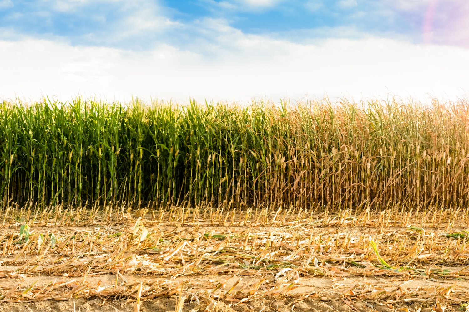
“We’re also seeing some agriculture impacts. Right now, in North Carolina, we’ve heard in recent weeks about things like leaf wilt on some of the soybeans and the cotton crops. Hearing more of that this week from places like Scotland County down in the Sandhills. Also hearing that the pastures down there are starting to go dormant a little bit early, so that could affect the hay harvest over the next few months. Again, the corn is mostly out of the field by this point, or at least mostly mature. But there are still some crops out there that need a little bit more rain—especially those soybeans, any of that cotton that hasn’t defoliated yet, and certainly those pastures and hay fields as well. So, the farmers, they’re wishing for a little bit more rain to break that dry spell here over the next few weeks.”
We’re talking about the dry spell and also the potential of wildfires, and one question I want to ask is: I’ve noticed a lot on my drives in and out of work that trees are already starting to lose their leaves. Could that be because of the lack of rain, and could that contribute to potential fire hazards?
“Yeah, absolutely. This time of the year, when you start to see those trees drop their leaves early, that’s because of moisture and drought stress. That’s the way for the trees to hold on to as much moisture as they can. They’re not having to send that moisture further out along the branches to the leaves. Easiest way to do that is just to drop those leaves off early. Some areas, we’re also hearing some of the leaves are changing color a little bit early. That can also be a sign that they’re a little bit too dry. We’re still a few weeks away from starting to see the first of those leaves turning at their more typical time of the year. And certainly, we know that in the fall, when you start to get that leaf drop, that is a big trigger of our fire season. So, any of these areas that are starting to see that early leaf drop could fuel more of the wildfire activity here over the next few weeks.”
Well, let’s take a look into the tropics real quick. I noticed that there’s a system in the tropics heading west toward the U.S. and the Carolinas. Talk about that. Is it going to be named anytime soon, and what potential impacts could we see?
“Yeah, after a few weeks without any named storms, we are finally seeing the tropics come back to life. Looks like we may have Hurricane Gabrielle by the weekend, and that system, like you said, is on a trajectory generally toward the eastern U.S. But we’re going to have a high-pressure system building over the Carolinas early next week that will act like a roadblock, and that will turn Gabrielle back out to sea. So, at this point, there is pretty good agreement among the forecast models that there will not be any major impacts in the Carolinas from Gabrielle—possibly some high surf and high rip currents, like we’ve seen throughout the summer with some of those offshore systems—but not expecting this to be a major impact locally. It is worth noting that even though it wasn’t a tropical storm, we did have some pretty big impacts earlier this week. Back on Monday and Tuesday, there was an offshore low-pressure system. Parts of northeastern North Carolina saw some really gusty winds. Some areas saw 50–60 mph wind gusts—actually a little bit higher than what we saw from Hurricane Erin a month ago—and also saw some pretty heavy rainfall totals, upwards of seven inches in southeastern Virginia. Certainly, those areas have seen the rain that they were looking for—and then some. But unfortunately, that rain was not very widespread across eastern North Carolina, so pretty limited totals in those areas from that storm earlier this week.”
Now, for anyone who’s listening who’s never lived at the beach: Is this a common thing during the hurricane season where you get these storms that really don’t form, but they still create some rain and wind gusts around coastal areas?
“You know, that’s the type of pattern that we would usually expect to see more in the fall and the winter going into the spring. If you hear about nor’easters, these are those types of events that are not named or tropical storms but can still be some really powerful coastal lows that bring those impacts—that bring the wind, that bring the rain, that bring some of the over wash. We’ve seen, even this past week down along the Outer Banks, another house has fallen into the ocean during that storm. But this time of the year, when we see those coastal events, they do tend to be tropical in nature. So, a little bit unusual that this was not a tropical storm. But also think back to one year ago. It was right around this time that we saw that non-tropical Potential Cyclone Eight right along our southern coast. So, it’s not unheard of to see the wind and the rain from a non-tropical storm this time of the year.”
Well, I guess we need to talk about the forecast coming up for the weekend. Is there any relief from the dryness and the drought for the farmers out there?
“Well, we’ll start with looking at the temperatures. You know, we’ve been enjoying that nice fall-like weather over the past few weeks. We’re going to see more of a return to summer-like conditions here over the next couple days. Looks like across parts of eastern North and South Carolina, those highs could hit the 90-degree mark later this afternoon under sunny skies—probably upper 80s in most areas tomorrow. Then, as we get into Sunday, we’ll start cooling off to more seasonable levels—mostly low to mid-80s—and we’ll see a little bit more cloud cover by Sunday. But getting to your question, Kyle, no great rain chances for the Carolinas over the next week. It looks like this dry pattern that we’ve been in will continue for at least the next seven days. So, the farmers out there, unfortunately, are going to have to tough it out with more dry weather.”